![](/images/other/stat-length.png)
![Randonnée Marche La Souche - Bauzon station- Méjean-plateau du grand Tanargue - Photo](https://media.geolcdn.com/t/1900/400/5666ce05-8e4a-41c4-aef3-79754851f3b9.jpg&format=pjpeg&maxdim=2)
Bauzon station- Méjean-plateau du grand Tanargue
coureursdecretes
Utilisateur
![Longueur](/images/other/stat-length.png)
Longueur
16,9 km
![Altitude max](https://static1.geolcdn.com/siteimages/upload/files/1508320355ic_sort_altitude_max_24dp.png)
Altitude max
1507 m
![Dénivelé positif](https://static1.geolcdn.com/siteimages/upload/files/1508320355ic_sort_den_pos_24dp.png)
Dénivelé positif
376 m
![Km-Effort](/images/other/stat-length.png)
Km-Effort
22 km
![Altitude min](https://static1.geolcdn.com/siteimages/upload/files/1508320355ic_sort_altitude_min_24dp.png)
Altitude min
1361 m
![Dénivelé négatif](https://static1.geolcdn.com/siteimages/upload/files/1508320355ic_sort_den_neg_24dp.png)
Dénivelé négatif
376 m
![Boucle](https://static1.geolcdn.com/siteimages/upload/files/16400158638029165_repeat_loop_refresh_sync_direction_icon.png)
Boucle
Oui
Date de création :
2024-07-01 07:45:16.574
Dernière modification :
2024-08-16 15:11:32.328
![Marche](https://static1.geolcdn.com/sitytour/trail-icons/101.png)
4h58
Difficulté : Très difficile
![Scannez ce code QR pour ouvrir la randonnée dans l'application SityTrail](https://capi.geolives.com/qq0zvz2zws4bq2lad0pu/sitytour/trails/4108400/qr.png?size=200)
Application GPS de randonnée GRATUITE
À propos
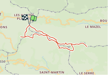
Randonnée Marche de 16,9 km à découvrir à Auvergne-Rhône-Alpes, Ardèche, La Souche. Cette randonnée est proposée par coureursdecretes.
Description
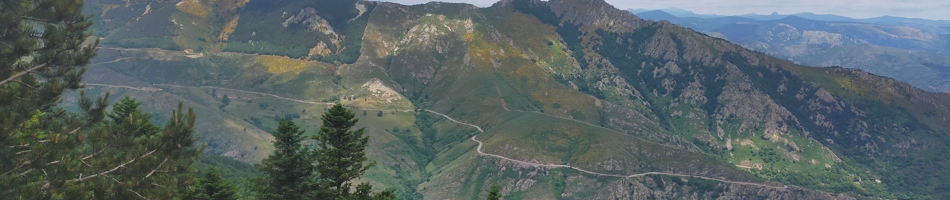
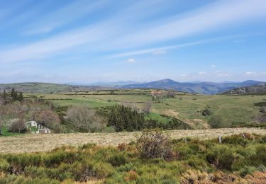
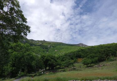
Une randonnée sur la partie la plus élevée du Tanargue. Panorama sur les crêtes, alpages, parcours didactique...peu de dénivelé, sentiers très praticables.
Localisation
Pays :
France
Région :
Auvergne-Rhône-Alpes
Département/Province :
Ardèche
Commune :
La Souche
Localité :
Unknown
Départ:(Dec)
Départ:(UTM)
586419 ; 4942361 (31T) N.
Commentaires
Randonnées à proximité
![Randonnée Marche Mayres - 07 rocher d abraham - Photo](https://media.geolcdn.com/t/375/260/ext.jpg?maxdim=2&url=https%3A%2F%2Fstatic1.geolcdn.com%2Fsiteimages%2Fupload%2Ffiles%2F1553511878bg_sport_marche.png)
![Marche Marche](https://static1.geolcdn.com/sitytour/trail-icons/101.png)
07 rocher d abraham
Marche
Moyen
(2)
Mayres,
Auvergne-Rhône-Alpes,
Ardèche,
France
![](/images/other/stat-length.png)
14 km | 28 km-effort
8h 4min
![](https://static1.geolcdn.com/siteimages/upload/files/16400158638029165_repeat_loop_refresh_sync_direction_icon.png)
Oui
![Randonnée Marche Borne - croix de beauzon - Photo](https://media.geolcdn.com/t/375/260/217677dd-c155-48af-bc87-419b5b32c8ce.jpg&format=jpg&maxdim=2)
![Marche Marche](https://static1.geolcdn.com/sitytour/trail-icons/101.png)
croix de beauzon
Marche
Difficile
Borne,
Auvergne-Rhône-Alpes,
Ardèche,
France
![](/images/other/stat-length.png)
13,6 km | 18,2 km-effort
5h 53min
![](https://static1.geolcdn.com/siteimages/upload/files/16400158638029165_repeat_loop_refresh_sync_direction_icon.png)
Oui
![Randonnée Marche Mayres - Mayres Chaumiène 12km - Photo](https://media.geolcdn.com/t/375/260/a133b020-a8a4-4863-bdb6-488ddda17997.jpg&format=jpg&maxdim=2)
![Marche Marche](https://static1.geolcdn.com/sitytour/trail-icons/101.png)
Mayres Chaumiène 12km
Marche
Difficile
Mayres,
Auvergne-Rhône-Alpes,
Ardèche,
France
![](/images/other/stat-length.png)
12,2 km | 23 km-effort
6h 43min
![](https://static1.geolcdn.com/siteimages/upload/files/16400158638029165_repeat_loop_refresh_sync_direction_icon.png)
Oui
![Randonnée Marche Valgorge - Le Tanargue - Photo](https://media.geolcdn.com/t/375/260/ad0e721e-bf17-4b50-b28e-4b195a037c98.jpg&format=jpg&maxdim=2)
![Marche Marche](https://static1.geolcdn.com/sitytour/trail-icons/101.png)
Le Tanargue
Marche
Difficile
Valgorge,
Auvergne-Rhône-Alpes,
Ardèche,
France
![](/images/other/stat-length.png)
13,7 km | 24 km-effort
5h 28min
![](https://static1.geolcdn.com/siteimages/upload/files/16400158638029165_repeat_loop_refresh_sync_direction_icon.png)
Oui
![Randonnée Marche Loubaresse - Loubaresse ruisseau de goutelles 10 km - Photo](https://media.geolcdn.com/t/375/260/7fb7aff1-6923-41f8-900d-5aa3bb3bfe91.jpg&format=jpg&maxdim=2)
![Marche Marche](https://static1.geolcdn.com/sitytour/trail-icons/101.png)
Loubaresse ruisseau de goutelles 10 km
Marche
Moyen
Loubaresse,
Auvergne-Rhône-Alpes,
Ardèche,
France
![](/images/other/stat-length.png)
10 km | 13,3 km-effort
2h 55min
![](https://static1.geolcdn.com/siteimages/upload/files/16400158638029165_repeat_loop_refresh_sync_direction_icon.png)
Oui
![Randonnée Marche Loubaresse - Loubaresse Nord 5,2 km - Photo](https://media.geolcdn.com/t/375/260/5ae50d28-b170-4d44-aab5-94560c77c18b.jpg&format=jpg&maxdim=2)
![Marche Marche](https://static1.geolcdn.com/sitytour/trail-icons/101.png)
Loubaresse Nord 5,2 km
Marche
Moyen
Loubaresse,
Auvergne-Rhône-Alpes,
Ardèche,
France
![](/images/other/stat-length.png)
5,2 km | 8,6 km-effort
2h 12min
![](https://static1.geolcdn.com/siteimages/upload/files/16400158638029165_repeat_loop_refresh_sync_direction_icon.png)
Oui
![Randonnée Marche Borne - Station Croix de Bauzon 14 km. - Photo](https://media.geolcdn.com/t/375/260/186f655e-2b32-453c-b04b-facbcec1469b.jpg&format=jpg&maxdim=2)
![Marche Marche](https://static1.geolcdn.com/sitytour/trail-icons/101.png)
Station Croix de Bauzon 14 km.
Marche
Difficile
Borne,
Auvergne-Rhône-Alpes,
Ardèche,
France
![](/images/other/stat-length.png)
13,9 km | 19,2 km-effort
4h 22min
![](https://static1.geolcdn.com/siteimages/upload/files/16400158638029165_repeat_loop_refresh_sync_direction_icon.png)
Oui
![Randonnée A pied Mayres - Tour des Poignets 18KM - Photo](https://media.geolcdn.com/t/375/260/4695ff56-51f7-439d-a787-0d719ef81c46.jpg&format=jpg&maxdim=2)
![A pied A pied](https://static1.geolcdn.com/sitytour/trail-icons/100.png)
Tour des Poignets 18KM
A pied
Moyen
Mayres,
Auvergne-Rhône-Alpes,
Ardèche,
France
![](/images/other/stat-length.png)
17,1 km | 25 km-effort
5h 42min
![](https://static1.geolcdn.com/siteimages/upload/files/16400158638029165_repeat_loop_refresh_sync_direction_icon.png)
Oui
![Randonnée Marche Saint-Étienne-de-Lugdarès - Le Bez-Borne-les Chambons - Photo](https://media.geolcdn.com/t/375/260/84516e8e-4390-46d3-bf0d-44f54607fcbb.jpg&format=jpg&maxdim=2)
![Marche Marche](https://static1.geolcdn.com/sitytour/trail-icons/101.png)
Le Bez-Borne-les Chambons
Marche
Difficile
Saint-Étienne-de-Lugdarès,
Auvergne-Rhône-Alpes,
Ardèche,
France
![](/images/other/stat-length.png)
14,1 km | 22 km-effort
5h 20min
![](https://static1.geolcdn.com/siteimages/upload/files/16400158638029165_repeat_loop_refresh_sync_direction_icon.png)
Oui